
Make a donation
Gear up for your next adventure:
As an Amazon Associate, this site earns from qualifying purchases at no extra cost to you.
Cesiomaggiore topographic map
Click on the map to display elevation.
Make a donation
Gear up for your next adventure:
As an Amazon Associate, this site earns from qualifying purchases at no extra cost to you.
About this map
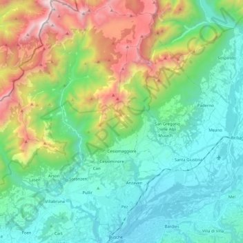
Name: Cesiomaggiore topographic map, elevation, terrain.
Location: Cesiomaggiore, Belluno, Veneto, 32030, Italië (46.03555 11.89297 46.17587 12.02003)
Average elevation: 846 m
Minimum elevation: 231 m
Maximum elevation: 2,473 m
Make a donation
Gear up for your next adventure:
As an Amazon Associate, this site earns from qualifying purchases at no extra cost to you.
Other topographic maps
Click on a map to view its topography, its elevation and its terrain.
Drei Zinnen
Italië > Veneto > Belluno > Auronzo di Cadore
Pas in 1933 slaagde er iemand in de Cima Grande ook via de noordkant te beklimmen, en dat was de Italiaanse legendarische bergbeklimmer Emilio Comici. De beklimming hiervan staat bekend als een hoogtepunt in de geschiedenis van de klimsport en werd de eerste beklimming die de moeilijkheidsgraad VI meekreeg.
Average elevation: 2,242 m
Make a donation
Gear up for your next adventure:
As an Amazon Associate, this site earns from qualifying purchases at no extra cost to you.