Geolocate

Lyme Park topographic map

Click on the map to display elevation.

About this map

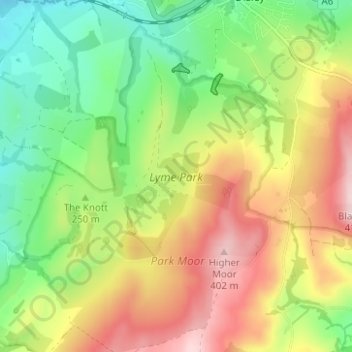
Name: Lyme Park topographic map, elevation, terrain.

Location: Lyme Park, Disley, Cheshire East, England, United Kingdom (53.32071 -2.07770 53.35787 -2.03700)

Average elevation: 260 m

Minimum elevation: 143 m

Maximum elevation: 409 m

Gear up for your next adventure:

🔋Solar Power Bank - Keep your GPS and devices charged during long outdoor trips
❄️Traction Ice Cleats - Slip-on spikes for icy trails and winter hiking
🎒Hiking Daypack - Lightweight and durable backpacks for day trips and excursions
🥽Outdoor Goggles - Protective eyewear for outdoor activities
🩹Moleskin Blister Pads - Direct protection for painful foot pressure points

As an Amazon Associate, this site earns from qualifying purchases at no extra cost to you.