Geolocate

Venice topographic map

Click on the map to display elevation.

About this map

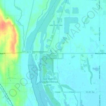
Name: Venice topographic map, elevation, terrain.

Location: Venice, Douglas County, Nebraska, 68073, United States (41.21389 -96.37364 41.25389 -96.33364)

Average elevation: 345 m

Minimum elevation: 336 m

Maximum elevation: 384 m

Other topographic maps

Click on a map to view its topography, its elevation and its terrain.

Boys Town

United States > Nebraska > Douglas County

Average elevation: 367 m

Valley

United States > Nebraska > Douglas County

Average elevation: 347 m

Waterloo

United States > Nebraska > Douglas County

Average elevation: 343 m

Memorial Park

United States > Nebraska > Douglas County > Omaha

Average elevation: 354 m

Gear up for your next adventure:

🦶Hiking Shoe Insoles - Added support for high arches and long days on feet
💡LED Camping Lantern - Illuminate your campsite with long-lasting lanterns
💡Portable Camping Lamp - Rechargeable lamp for campsite lighting
🧦Crew Hiking Socks - Comfortable socks for long-distance hikes
🔨Vehicle Emergency Tool - Safety tool for remote road trips to trailheads

As an Amazon Associate, this site earns from qualifying purchases at no extra cost to you.