Geolocate

Helicon topographic map

Click on the map to display elevation.

About this map

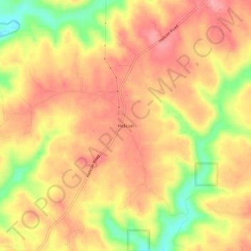
Name: Helicon topographic map, elevation, terrain.

Location: Helicon, Winston County, Alabama, United States (34.10621 -87.15834 34.14621 -87.11834)

Average elevation: 232 m

Minimum elevation: 163 m

Maximum elevation: 271 m

Other topographic maps

Click on a map to view its topography, its elevation and its terrain.

Haleyville

United States > Alabama > Winston County

Average elevation: 261 m

Double Springs

United States > Alabama > Winston County

Average elevation: 226 m

Addison

United States > Alabama > Winston County

Average elevation: 237 m

Arley

United States > Alabama > Winston County

Average elevation: 208 m

Gear up for your next adventure:

🏕️Camping Hammock - Integrated protection for sleeping between trees
🗺️Topographic Maps - Detailed maps to explore trails, mountains, and wilderness areas
🧥Softshell Hiking Jacket - The perfect balance of wind protection and breathability
🧊Insulated Water Bottle - Keeps drinks cold in summer and prevents freezing in winter
🥾Lightweight Hiking Shoes - Comfortable shoes for day hikes

As an Amazon Associate, this site earns from qualifying purchases at no extra cost to you.