Geolocate

Addison topographic map

Click on the map to display elevation.

About this map

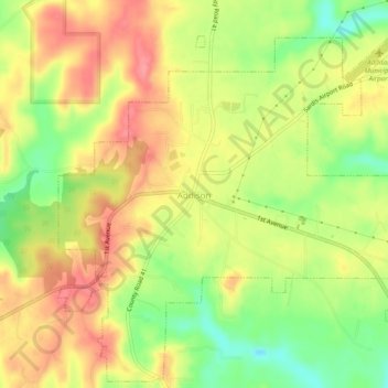
Name: Addison topographic map, elevation, terrain.

Location: Addison, Winston County, Alabama, United States (34.18295 -87.19854 34.22180 -87.14982)

Average elevation: 237 m

Minimum elevation: 190 m

Maximum elevation: 274 m

Other topographic maps

Click on a map to view its topography, its elevation and its terrain.

Center

United States > Alabama > Winston County

Average elevation: 279 m

Helicon

United States > Alabama > Winston County

Average elevation: 232 m

Gear up for your next adventure:

🧰Emergency Multi-Tool - Compact multi-tool for outdoor survival
🛌Down Sleeping Bag - Superior warmth-to-weight ratio for cold nights
🧥Waterproof Jacket - Lightweight rain jackets for hiking and outdoor activities
📷Outdoor Action Camera - Capture high-elevation views and rugged adventures
🥾Hiking Shoes - Durable and comfortable shoes for trail hiking

As an Amazon Associate, this site earns from qualifying purchases at no extra cost to you.