Geolocate

kolymannu topographic map

Click on the map to display elevation.

About this map

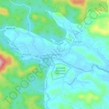
Name: kolymannu topographic map, elevation, terrain.

Location: kolymannu, Mananthavady, Wayanad, Kerala, 670552, India (11.80868 75.82644 11.84868 75.86644)

Average elevation: 776 m

Minimum elevation: 724 m

Maximum elevation: 973 m

Other topographic maps

Click on a map to view its topography, its elevation and its terrain.

Mazhuvannoor

India > Kerala > Mananthavady > Mazhuvannur

Average elevation: 733 m

Vellamunda

India > Kerala > Mananthavady > Peechamcode

Average elevation: 812 m

Kattikulam

India > Kerala > Mananthavady > Kattikkulam

Average elevation: 772 m

Gear up for your next adventure:

🧭Orienteering Kit - Tools for map reading and navigation in the wild
🧦Crew Hiking Socks - Comfortable socks for long-distance hikes
Camping Tent - Weather-resistant tents suitable for 2 to 6 people
🪑Insulated Seat Pad - Protect your seat from cold rocks and wet logs
🌡️Emergency Mylar Blankets - Compact thermal protection for unexpected nights outdoors

As an Amazon Associate, this site earns from qualifying purchases at no extra cost to you.