Geolocate

Longboat Key topographic map

Click on the map to display elevation.

About this map

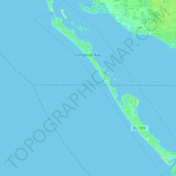
Name: Longboat Key topographic map, elevation, terrain.

Location: Longboat Key, Manatee County, Florida, 34228, United States (27.32116 -82.70448 27.45352 -82.57927)

Average elevation: 1 m

Minimum elevation: -1 m

Maximum elevation: 20 m

Other topographic maps

Click on a map to view its topography, its elevation and its terrain.

Parrish

United States > Florida > Manatee County

Average elevation: 12 m

Memphis

United States > Florida > Manatee County > Memphis

Average elevation: 5 m

Holmes Beach

United States > Florida > Manatee County

Average elevation: 1 m

Memphis

United States > Florida > Manatee County > Memphis

Average elevation: 6 m

Gear up for your next adventure:

Camping Tent - Weather-resistant tents suitable for 2 to 6 people
🧰Survival Kit - Essential gear for emergencies in the wilderness
🔦LED Headlamp - Hands-free lighting for early morning starts or late finishes
❄️Traction Ice Cleats - Slip-on spikes for icy trails and winter hiking
🛏️Camping Sleeping Mat - Comfortable mats for sleeping outdoors

As an Amazon Associate, this site earns from qualifying purchases at no extra cost to you.