Brighton topographic map
Interactive map
Click on the map to display elevation.
About this map
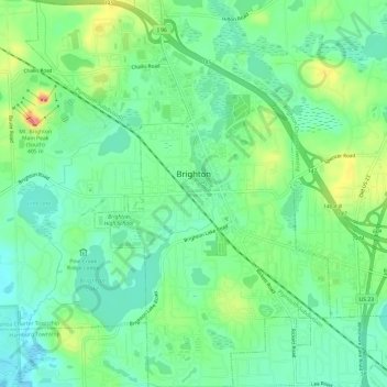
Name: Brighton topographic map, elevation, terrain.
Location: Brighton, Livingston County, Michigan, 48116, United States (42.50734 -83.81074 42.55146 -83.76346)
Average elevation: 287 m
Minimum elevation: 263 m
Maximum elevation: 336 m
Other topographic maps
Click on a map to view its topography, its elevation and its terrain.
Hell
United States > Michigan > Livingston County > Putnam Township
Hell, Putnam Township, Livingston County, Michigan, United States
Average elevation: 277 m
Howell
United States > Michigan > Livingston County
Howell, Livingston County, Michigan, United States
Average elevation: 282 m
Marion Township
United States > Michigan > Livingston County > Marion Township
Marion Township, Livingston County, Michigan, United States
Average elevation: 288 m