
Thank you for supporting this site ❤️
Make a donation
Make a donation
Gear up for your next adventure:
As an Amazon Associate, this site earns from qualifying purchases at no extra cost to you.
Potterville topographic map
Click on the map to display elevation.
Thank you for supporting this site ❤️
Make a donation
Make a donation
Gear up for your next adventure:
As an Amazon Associate, this site earns from qualifying purchases at no extra cost to you.
About this map
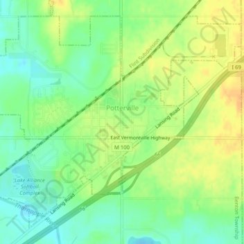
Name: Potterville topographic map, elevation, terrain.
Location: Potterville, Eaton County, Michigan, 48876, United States (42.61490 -84.75909 42.64013 -84.71964)
Average elevation: 275 m
Minimum elevation: 259 m
Maximum elevation: 291 m
Thank you for supporting this site ❤️
Make a donation
Make a donation
Gear up for your next adventure:
As an Amazon Associate, this site earns from qualifying purchases at no extra cost to you.
Other topographic maps
Click on a map to view its topography, its elevation and its terrain.
Grand Ledge
United States > Michigan > Eaton County > Grand Ledge > Grand Ledge
Average elevation: 259 m