Geolocate

Puembo topographic map

Click on the map to display elevation.

About this map

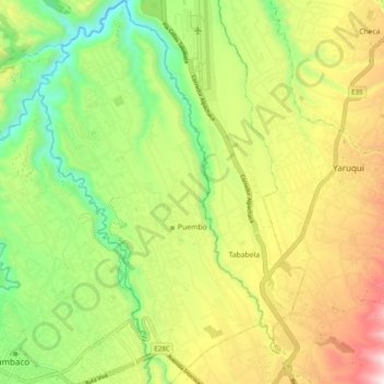
Name: Puembo topographic map, elevation, terrain.

Location: Puembo, Quito Canton, Pichincha, 170905, Ecuador (-0.21788 -78.39759 -0.11967 -78.33991)

Average elevation: 2,427 m

Minimum elevation: 2,020 m

Maximum elevation: 2,966 m

Other topographic maps

Click on a map to view its topography, its elevation and its terrain.

San Miguel del Común

Ecuador > Pichincha > Quito Canton

Average elevation: 2,536 m

La Victoria

Ecuador > Pichincha > Quito Canton > Yaruquí

Average elevation: 2,530 m

Calderón

Ecuador > Pichincha > Quito Canton

Average elevation: 2,542 m

Gear up for your next adventure:

🧥Packable Rain Jacket - Breathable waterproof layer for unpredictable weather
🧴Waterproofing Spray - Restore the DWR coating on jackets and tents
🚲MTB Frame Bag - Carry tools and maps directly on your bicycle frame
🧦Crew Hiking Socks - Comfortable socks for long-distance hikes
🔭Compact Binoculars - Lightweight optics for scouting trails and wildlife

As an Amazon Associate, this site earns from qualifying purchases at no extra cost to you.