
Watts Point topographic map
Click on the map to display elevation.
About this map
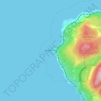
Name: Watts Point topographic map, elevation, terrain.
Average elevation: 44 m
Minimum elevation: 0 m
Maximum elevation: 306 m
Other topographic maps
Click on a map to view its topography, its elevation and its terrain.
Stawamus Chief Provincial Park
Canada > British Columbia > Squamish-Lillooet Regional District > Squamish
Average elevation: 433 m
Edith Lake
Canada > British Columbia > Squamish-Lillooet Regional District > Squamish
Average elevation: 309 m
Alice Lake
Canada > British Columbia > Squamish-Lillooet Regional District > Squamish
Average elevation: 247 m
Cheakamus River
Canada > British Columbia > Squamish-Lillooet Regional District > Squamish
Average elevation: 266 m