Geolocate

Texarkana topographic map

Click on the map to display elevation.

About this map

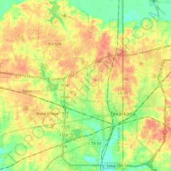
Name: Texarkana topographic map, elevation, terrain.

Location: Texarkana, Bowie County, Texas, United States (33.38139 -94.17097 33.51196 -94.04304)

Average elevation: 99 m

Minimum elevation: 74 m

Maximum elevation: 122 m

Other topographic maps

Click on a map to view its topography, its elevation and its terrain.

Old Salem

United States > Texas > Bowie County

Average elevation: 110 m

Eylau

United States > Texas > Bowie County

Average elevation: 93 m

Eylau

United States > Texas > Bowie County

Average elevation: 93 m

Gear up for your next adventure:

🥾Hiking Shoes - Durable and comfortable shoes for trail hiking
🥾Lightweight Hiking Shoes - Comfortable shoes for day hikes
💡Solar Camping Lamp - Eco-friendly lighting for campsites
👟Leg Gaiters - Keep debris, mud, and snow out of your boots
🧶550 Survival Paracord - Versatile utility cord for emergency repairs and rigging

As an Amazon Associate, this site earns from qualifying purchases at no extra cost to you.