Geolocate

Bernal topographic map

Click on the map to display elevation.

About this map

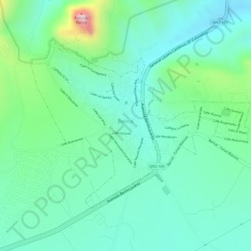
Name: Bernal topographic map, elevation, terrain.

Location: Bernal, Ezequiel Montes, Querétaro, Mexico (20.72957 -99.95204 20.74746 -99.92667)

Average elevation: 2,102 m

Minimum elevation: 2,005 m

Maximum elevation: 2,374 m

Other topographic maps

Click on a map to view its topography, its elevation and its terrain.

Bernal boulder

Mexico > Querétaro > Ezequiel Montes

Average elevation: 2,120 m

Gear up for your next adventure:

🚲Heavy Duty Bike Lock - Secure your bike at the trailhead or during stops
🧦Hiking Liner Socks - Thin base layer to prevent friction and blisters
🥾Light Trekking Boots - Supportive boots for multi-day treks
🥾Hiking Shorts - Breathable shorts suitable for summer hikes
🛰️Satellite Messenger - Emergency communication for areas with no cell service

As an Amazon Associate, this site earns from qualifying purchases at no extra cost to you.