
Abrantes topographic map
Interactive map
Click on the map to display elevation.
About this map
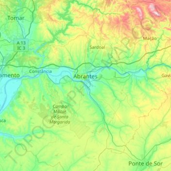
Name: Abrantes topographic map, elevation, terrain.
Location: Abrantes, Santarém, Médio Tejo, Centro, Portugal (39.23331 -8.35557 39.64649 -7.93946)
Average elevation: 185 m
Minimum elevation: 12 m
Maximum elevation: 636 m
An active republican center, Abrantes was the place of preparatory meetings for the 5 October 1910 Revolution, which may have contributed to the village's elevation to the status of city on 14 June 1916.
Other topographic maps
Click on a map to view its topography, its elevation and its terrain.
Marianas
Portugal > Centro > Figueira da Foz > Marianas
Marianas, Bom Sucesso, Figueira da Foz, Coimbra, Baixo Mondego, Centro, 3090-448, Portugal
Average elevation: 52 m
Figueira da Foz
Portugal > Centro > Buarcos e São Julião > Figueira da Foz
Figueira da Foz, Buarcos e São Julião, Figueira da Foz, Coimbra, Baixo Mondego, Centro, 3080-118, Portugal
Average elevation: 26 m
Olho Marinho
Portugal > Centro > Olho Marinho
Olho Marinho, Óbidos, Leiria, West, Centro, Portugal
Average elevation: 80 m
Caldas da Rainha
Caldas da Rainha, Leiria, West, Centro, Portugal
Average elevation: 97 m
Lousã e Vilarinho
Portugal > Centro > Lousã e Vilarinho
Lousã e Vilarinho, Lousã, Coimbra, Pinhal Interior Norte, Centro, Portugal
Average elevation: 431 m
Chainça
Portugal > Centro > Santa Catarina da Serra e Chainça
Chainça, Santa Catarina da Serra e Chainça, Leiria, Pinhal Litoral, Centro, Portugal
Average elevation: 356 m
Caldas da Rainha
Portugal > Centro > Caldas da Rainha
Caldas da Rainha, CLD, Leiria, West, Centro, 2500-253, Portugal
Average elevation: 58 m
Porto de Mós
Portugal > Centro > Porto de Mós
Porto de Mós, Leiria, Pinhal Litoral, Centro, Portugal
Average elevation: 222 m