
Largo Inconfidencia topographic map
Click on the map to display elevation.
About this map
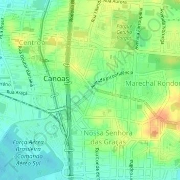
Name: Largo Inconfidencia topographic map, elevation, terrain.
Average elevation: 18 m
Minimum elevation: 2 m
Maximum elevation: 39 m
Other topographic maps
Click on a map to view its topography, its elevation and its terrain.
Niterói
Brasil > Rio Grande do Sul > Região Metropolitana de Porto Alegre > Canoas
Average elevation: 7 m
Marechal Rondon
Brasil > Rio Grande do Sul > Região Metropolitana de Porto Alegre > Canoas
Average elevation: 25 m
Mato Grande
Brasil > Rio Grande do Sul > Região Metropolitana de Porto Alegre > Canoas
Average elevation: 7 m
Mathias Velho
Brasil > Rio Grande do Sul > Região Metropolitana de Porto Alegre > Canoas
Average elevation: 5 m
Canoas
Brasil > Rio Grande do Sul > Região Metropolitana de Porto Alegre > Canoas
Atinge uma altitude de oito metros ao nível do mar. Em seu território correm as águas dos rios Gravataí e Sinos.
Average elevation: 30 m
Guajuviras
Brasil > Rio Grande do Sul > Região Metropolitana de Porto Alegre > Canoas
Average elevation: 33 m
Brigadeira
Brasil > Rio Grande do Sul > Região Metropolitana de Porto Alegre > Canoas
Average elevation: 23 m
Rio Branco
Brasil > Rio Grande do Sul > Região Metropolitana de Porto Alegre > Canoas
Average elevation: 5 m
Harmonia
Brasil > Rio Grande do Sul > Região Metropolitana de Porto Alegre > Canoas
Average elevation: 6 m
Estância Velha
Brasil > Rio Grande do Sul > Região Metropolitana de Porto Alegre > Canoas
Average elevation: 32 m
Centro
Brasil > Rio Grande do Sul > Região Metropolitana de Porto Alegre > Canoas
Average elevation: 12 m
Igara
Brasil > Rio Grande do Sul > Região Metropolitana de Porto Alegre > Canoas
Average elevation: 29 m
Fátima
Brasil > Rio Grande do Sul > Região Metropolitana de Porto Alegre > Canoas
Average elevation: 6 m
São José
Brasil > Rio Grande do Sul > Região Metropolitana de Porto Alegre > Canoas
Average elevation: 17 m
Praça Julio Pereira de Souza
Brasil > Rio Grande do Sul > Região Metropolitana de Porto Alegre > Canoas
Average elevation: 34 m