
Make a donation
Gear up for your next adventure:
As an Amazon Associate, this site earns from qualifying purchases at no extra cost to you.
Estância Velha topographic map
Click on the map to display elevation.
Make a donation
Gear up for your next adventure:
As an Amazon Associate, this site earns from qualifying purchases at no extra cost to you.
About this map
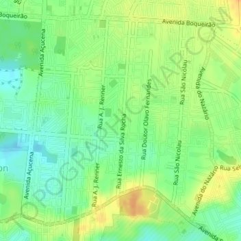
Name: Estância Velha topographic map, elevation, terrain.
Average elevation: 32 m
Minimum elevation: 16 m
Maximum elevation: 50 m
Make a donation
Gear up for your next adventure:
As an Amazon Associate, this site earns from qualifying purchases at no extra cost to you.
Other topographic maps
Click on a map to view its topography, its elevation and its terrain.
Canoas
Brasil > Rio Grande do Sul > Região Metropolitana de Porto Alegre > Canoas
Atinge uma altitude de oito metros ao nível do mar. Em seu território correm as águas dos rios Gravataí e Sinos.
Average elevation: 30 m
Parque Getúlio Vargas
Brasil > Rio Grande do Sul > Região Metropolitana de Porto Alegre > Canoas
Average elevation: 22 m
Praça Moinhos de Vento II
Brasil > Rio Grande do Sul > Região Metropolitana de Porto Alegre > Canoas
Average elevation: 29 m
Praça Barão do Rio Branco
Brasil > Rio Grande do Sul > Região Metropolitana de Porto Alegre > Canoas
Average elevation: 10 m
Make a donation
Gear up for your next adventure:
As an Amazon Associate, this site earns from qualifying purchases at no extra cost to you.
Praça Cristóvão Colombo
Brasil > Rio Grande do Sul > Região Metropolitana de Porto Alegre > Canoas
Average elevation: 9 m
Arroio Araçá
Brasil > Rio Grande do Sul > Região Metropolitana de Porto Alegre > Canoas
Average elevation: 16 m
Praça Parque São José
Brasil > Rio Grande do Sul > Região Metropolitana de Porto Alegre > Canoas
Average elevation: 19 m
Praça Hércules
Brasil > Rio Grande do Sul > Região Metropolitana de Porto Alegre > Canoas
Average elevation: 29 m
Make a donation
Gear up for your next adventure:
As an Amazon Associate, this site earns from qualifying purchases at no extra cost to you.
Largo Inconfidencia
Brasil > Rio Grande do Sul > Região Metropolitana de Porto Alegre > Canoas
Average elevation: 18 m