Geolocate

Kexby topographic map

Click on the map to display elevation.

About this map

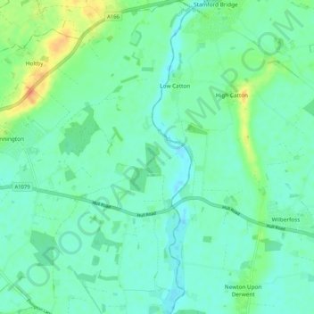
Name: Kexby topographic map, elevation, terrain.

Location: Kexby, York, York and North Yorkshire, England, United Kingdom (53.93060 -0.98973 53.99150 -0.92031)

Average elevation: 15 m

Minimum elevation: 5 m

Maximum elevation: 42 m

Other topographic maps

Click on a map to view its topography, its elevation and its terrain.

Towthorpe

United Kingdom > England > York > York

Average elevation: 18 m

Knapton

United Kingdom > England > York > York

Average elevation: 18 m

Hob Moor

United Kingdom > England > York > York

Average elevation: 16 m

Crockey Hill

United Kingdom > England > York > York > Crockey Hill

Average elevation: 10 m

Gear up for your next adventure:

🔭Compact Binoculars - Lightweight optics for scouting trails and wildlife
🌬️Windproof Camp Stove - Efficient cooking even on exposed mountain peaks
🥾Trail Hiking Shoes - Durable shoes designed for rugged trails
🥾Lightweight Hiking Boots - Boots for comfort and mobility on long hikes
🧤Thermal Hiking Gloves - Grip-enhanced gloves for cold-weather altitude trekking

As an Amazon Associate, this site earns from qualifying purchases at no extra cost to you.