Geolocate

Guba topographic map

Click on the map to display elevation.

About this map

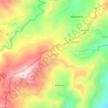
Name: Guba topographic map, elevation, terrain.

Location: Guba, Cebu City, Central Visayas, Philippines (10.40823 123.86990 10.44823 123.90990)

Average elevation: 361 m

Minimum elevation: 77 m

Maximum elevation: 624 m

Other topographic maps

Click on a map to view its topography, its elevation and its terrain.

Butuanon River

Philippines > Cebu City

Average elevation: 44 m

Fort San Pedro

Philippines > Cebu City

Average elevation: 3 m

San Roque

Philippines > Cebu City

Average elevation: 4 m

Hippodromo Park

Philippines > Cebu City

Average elevation: 13 m

Pari-an

Philippines > Cebu City

Average elevation: 8 m

TIEZA Pond

Philippines > Cebu City > Malubog

Average elevation: 471 m

Guadalupe River

Philippines > Cebu City

Average elevation: 220 m

Butuanon River

Philippines > Cebu City

Average elevation: 105 m

Kotkot River

Philippines > Cebu City

Average elevation: 316 m

SM Tower

Philippines > Cebu City

Average elevation: 3 m

Butuanon River

Philippines > Cebu City

Average elevation: 85 m

Butuanon River

Philippines > Cebu City

Average elevation: 41 m

CBP Central Park

Philippines > Cebu City

Average elevation: 19 m

Butuanon River

Philippines > Cebu City

Average elevation: 230 m

Sambag I

Philippines > Cebu City

Average elevation: 14 m

Mananga River

Philippines > Cebu City > Buot

Average elevation: 351 m

Buhisan Dam

Philippines > Cebu City > To-ong > Puti

Average elevation: 221 m

Gear up for your next adventure:

🧴Bear Spray Holster - Quick-access carry for essential Canadian wilderness safety
🥾Trail Running Boots - Durable shoes designed for trail running
🔭Compact Monocular - One-handed bird watching and trail spotting
🧦Merino Wool Socks - Moisture-wicking comfort for long-distance hiking
🧴Outdoor Sunscreen - High SPF protection for high-altitude UV exposure

As an Amazon Associate, this site earns from qualifying purchases at no extra cost to you.