
Make a donation
Gear up for your next adventure:
As an Amazon Associate, this site earns from qualifying purchases at no extra cost to you.
Fourqueux topographic map
Click on the map to display elevation.
Make a donation
Gear up for your next adventure:
As an Amazon Associate, this site earns from qualifying purchases at no extra cost to you.
About this map
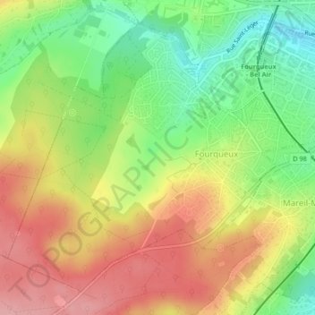
Name: Fourqueux topographic map, elevation, terrain.
Average elevation: 111 m
Minimum elevation: 48 m
Maximum elevation: 184 m
Make a donation
Gear up for your next adventure:
As an Amazon Associate, this site earns from qualifying purchases at no extra cost to you.
Other topographic maps
Click on a map to view its topography, its elevation and its terrain.
Fontaine de l'Étoile de Montaigu
France > Île-de-France > Yvelines > Saint-Germain-en-Laye
Average elevation: 126 m
Les Sables du Moulin À Vent Ou la Route
France > Île-de-France > Yvelines > Saint-Germain-en-Laye > Fourqueux
Average elevation: 116 m
Make a donation
Gear up for your next adventure:
As an Amazon Associate, this site earns from qualifying purchases at no extra cost to you.
La Vente
France > Île-de-France > Yvelines > Saint-Germain-en-Laye > Fourqueux
Average elevation: 118 m