
Make a donation
Gear up for your next adventure:
As an Amazon Associate, this site earns from qualifying purchases at no extra cost to you.
La Vieille Butte topographic map
Click on the map to display elevation.
Make a donation
Gear up for your next adventure:
As an Amazon Associate, this site earns from qualifying purchases at no extra cost to you.
About this map
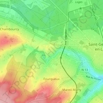
Name: La Vieille Butte topographic map, elevation, terrain.
Average elevation: 95 m
Minimum elevation: 33 m
Maximum elevation: 182 m
Make a donation
Gear up for your next adventure:
As an Amazon Associate, this site earns from qualifying purchases at no extra cost to you.
Other topographic maps
Click on a map to view its topography, its elevation and its terrain.
Saint-Germain-en-Laye
France > Île-de-France > Yvelines > Saint-Germain-en-Laye
Le territoire communal s'étend sur un plateau limité de façon abrupte vers l'est, culminant à 90 mètres à l'emplacement du château. Le rebord du plateau, matérialisé partiellement par la Terrasse, correspond à la limite intercommunale séparant Saint-Germain du Pecq, située en contrebas en bord de…
Average elevation: 52 m
Château de Saint-Germain-en-Laye
France > Île-de-France > Yvelines > Saint-Germain-en-Laye
Average elevation: 62 m
Make a donation
Gear up for your next adventure:
As an Amazon Associate, this site earns from qualifying purchases at no extra cost to you.