
Detling topographic map
Click on the map to display elevation.
About this map
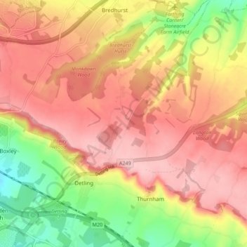
Name: Detling topographic map, elevation, terrain.
Location: Detling, Maidstone, Kent, England, United Kingdom (51.28100 0.55543 51.33376 0.60705)
Average elevation: 137 m
Minimum elevation: 38 m
Maximum elevation: 203 m
Other topographic maps
Click on a map to view its topography, its elevation and its terrain.
The Hernitage and High Noon Farm
United Kingdom > England > Kent > Maidstone > Detling
Average elevation: 145 m