
Make a donation
Gear up for your next adventure:
As an Amazon Associate, this site earns from qualifying purchases at no extra cost to you.
Benghazi topographic map
Click on the map to display elevation.
Make a donation
Gear up for your next adventure:
As an Amazon Associate, this site earns from qualifying purchases at no extra cost to you.
Benghazi
The largest Ottoman architectural monument in Benghazi is the late 19th-century Ottoman palace in El-Berka; built during the rule of Rashid Pasha II. The front elevation was completed in 1895, whilst the side sections were added later during Italian rule. The white and green structure houses 360 rooms; and is on a tract of land where Gamal Abdel Nasser Street meets al-Saqzali Street; south of the 28 March football stadium.
Make a donation
Gear up for your next adventure:
As an Amazon Associate, this site earns from qualifying purchases at no extra cost to you.
About this map
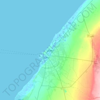
Name: Benghazi topographic map, elevation, terrain.
Location: Benghazi, Libya (31.96883 19.92172 32.28883 20.24172)
Average elevation: 23 m
Minimum elevation: -8 m
Maximum elevation: 148 m
Make a donation
Gear up for your next adventure:
As an Amazon Associate, this site earns from qualifying purchases at no extra cost to you.
Other topographic maps
Click on a map to view its topography, its elevation and its terrain.
Jabal al Gharbi
Libya has mostly a flat undulating plain and occasional plateau, with an average elevation of around 423 m (1,388 ft). Around 91 per cent of the land is covered by desert, with only 8.8 per cent agricultural land (with only 1% arable lands) and 0.1 per cent of forests. The major resources are petroleum, gypsum…
Average elevation: 451 m