
Make a donation
Gear up for your next adventure:
As an Amazon Associate, this site earns from qualifying purchases at no extra cost to you.
Stadt Hohenems topographic map
Click on the map to display elevation.
Make a donation
Gear up for your next adventure:
As an Amazon Associate, this site earns from qualifying purchases at no extra cost to you.
Stadt Hohenems
The town is located at 432 metres (1,417 feet) above sea level, about 16 km (10 miles) south of Lake Constance. Hohenems extends for 5.5 km (3.4 mi) from north to south and 8.2 km (5.1 mi) from west to east. Its total area is 29 square kilometres (11 sq mi), of which 42% is covered with forest. The oxbow lake of the river Rhine in the west, forming the border of Austria as well as EU to Switzerland, and the mountainside in the east is at the narrowest point of the Austrian Rhine valley. The Schlossberg ("castle mountain"), elevation 740 metres (2,428 feet), offers a distinctive backdrop to the town center.
Make a donation
Gear up for your next adventure:
As an Amazon Associate, this site earns from qualifying purchases at no extra cost to you.
About this map
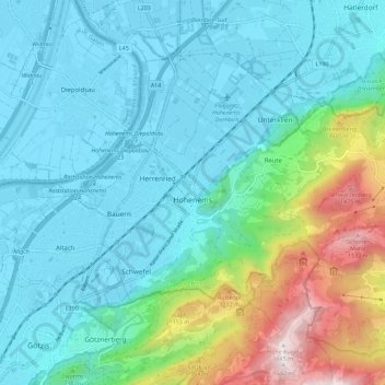
Name: Stadt Hohenems topographic map, elevation, terrain.
Location: Stadt Hohenems, Bezirk Dornbirn, Vorarlberg, 6845, Austria (47.33757 9.64955 47.39322 9.76241)
Average elevation: 660 m
Minimum elevation: 402 m
Maximum elevation: 1,636 m
Make a donation
Gear up for your next adventure:
As an Amazon Associate, this site earns from qualifying purchases at no extra cost to you.
Other topographic maps
Click on a map to view its topography, its elevation and its terrain.
Montafon
Austria > Vorarlberg > Bezirk Bludenz > Gemeinde Sankt Gallenkirch
Tourism plays a vital role and the Montafon is well-known for its skiing, hiking, and mountain biking. The Silvretta high alpine road (German: Hochalpenstraße) gives access to remote ski areas that are located altitudes of 650 to 1,430 meters. The construction of the Montafon Railway in 1905 also helped…
Average elevation: 1,566 m