Geolocate

Upthorpe topographic map

Click on the map to display elevation.

About this map

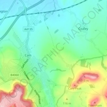
Name: Upthorpe topographic map, elevation, terrain.

Location: Upthorpe, Cam, Stroud, Gloucestershire, England, GL11 5HP, United Kingdom (51.68253 -2.36994 51.72253 -2.32994)

Average elevation: 74 m

Minimum elevation: 18 m

Maximum elevation: 216 m

Other topographic maps

Click on a map to view its topography, its elevation and its terrain.

Cam

United Kingdom > England > Gloucestershire > Stroud > Cam

Average elevation: 69 m

Gear up for your next adventure:

🦶Hiking Shoe Insoles - Added support for high arches and long days on feet
🧴Sunscreen SPF - Broad-spectrum sunscreen for outdoor activities
🥾Mountaineering Boots - Supportive boots for climbing and high-altitude hiking
🔦LED Headtorch - Bright and durable light for night activities
🔭Outdoor Binoculars - Lightweight binoculars for birdwatching and hiking

As an Amazon Associate, this site earns from qualifying purchases at no extra cost to you.