
Make a donation
Gear up for your next adventure:
As an Amazon Associate, this site earns from qualifying purchases at no extra cost to you.
Felchta topographic map
Click on the map to display elevation.
Make a donation
Gear up for your next adventure:
As an Amazon Associate, this site earns from qualifying purchases at no extra cost to you.
About this map
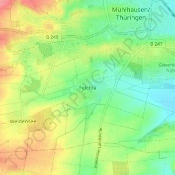
Name: Felchta topographic map, elevation, terrain.
Average elevation: 228 m
Minimum elevation: 196 m
Maximum elevation: 273 m
Make a donation
Gear up for your next adventure:
As an Amazon Associate, this site earns from qualifying purchases at no extra cost to you.
Other topographic maps
Click on a map to view its topography, its elevation and its terrain.
Weinbergen
Deutschland > Thüringen > Unstrut-Hainich-Kreis > Mühlhausen
Die Gemeinde Weinbergen schloss im Nordwesten an das Stadtgebiet von Mühlhausen/Thüringen an. Im Nordosten grenzte sie an Körner, im Südosten an die Verwaltungsgemeinschaft Unstrut-Hainich und im Westen an die Landgemeinde Vogtei. Das Gemeindegebiet lag in der Höhenlage zwischen 182 m ü. NN an der…
Average elevation: 223 m