
Make a donation
Gear up for your next adventure:
As an Amazon Associate, this site earns from qualifying purchases at no extra cost to you.
Weinbergen topographic map
Click on the map to display elevation.
Make a donation
Gear up for your next adventure:
As an Amazon Associate, this site earns from qualifying purchases at no extra cost to you.
Weinbergen
The municipality of Weinbergen adjoined the urban area of Mühlhausen to the northwest. To the north-east it bordered on Körner, to the south-east on the administrative community of Unstrut-Hainich and to the west on the rural municipality of Vogtei. The municipality's altitude ranged from 182 m (597 ft) above NN on the Unstrut near Seebach to 389.8 m (1,279 ft) above NN on the Forstberg hill in the north.
Make a donation
Gear up for your next adventure:
As an Amazon Associate, this site earns from qualifying purchases at no extra cost to you.
About this map
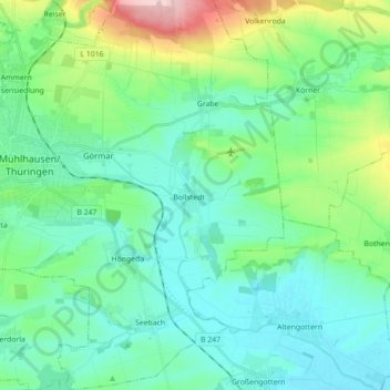
Name: Weinbergen topographic map, elevation, terrain.
Average elevation: 223 m
Minimum elevation: 174 m
Maximum elevation: 397 m
Make a donation
Gear up for your next adventure:
As an Amazon Associate, this site earns from qualifying purchases at no extra cost to you.