
Tucson topographic map
Interactive map
Click on the map to display elevation.
About this map
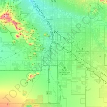
Name: Tucson topographic map, elevation, terrain.
Location: Tucson, Pima County, Arizona, United States (31.99041 -111.05823 32.32091 -110.70821)
Average elevation: 822 m
Minimum elevation: 651 m
Maximum elevation: 1,416 m
By 1900, 7,531 people lived in Tucson. By 1910, the population increased to 13,913. About this time, the U.S. Veterans Administration had begun construction of the present Veterans Hospital. The city's clean, dry air made it a destination for many veterans who had been gassed in World War I and needed respiratory therapy. In addition, these dry and high-altitude conditions were thought to be ideal for the treatment of tuberculosis, for which no cures were known before antibiotics were developed against it.
Other topographic maps
Click on a map to view its topography, its elevation and its terrain.
South Tucson
United States > Arizona > Pima County
South Tucson, Pima County, Arizona, United States
Average elevation: 741 m
Ajo
United States > Arizona > Pima County
Ajo, Pima County, Arizona, 85321, United States
Average elevation: 541 m
San Agustin
United States > Arizona > Pima County
San Agustin, Chukut Kuk District, Pima County, Arizona, United States
Average elevation: 936 m
Oro Valley
United States > Arizona > Pima County > Oro Valley
Oro Valley, Pima County, Arizona, 85737, United States
Average elevation: 874 m