Geolocate

Oro Valley topographic map

Click on the map to display elevation.

About this map

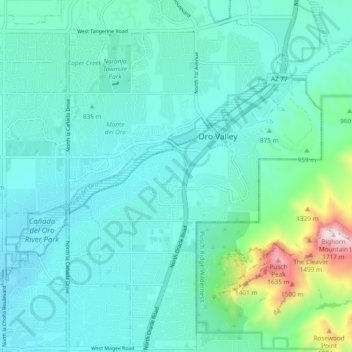
Name: Oro Valley topographic map, elevation, terrain.

Location: Oro Valley, Pima County, Arizona, 85737, United States (32.35091 -111.00649 32.43091 -110.92649)

Average elevation: 874 m

Minimum elevation: 714 m

Maximum elevation: 1,721 m

Gear up for your next adventure:

💡Solar Camping Lamp - Eco-friendly lighting for campsites
🥫Freeze-Dried Meals - Lightweight, high-calorie nutrition for multi-day treks
🛏️Camping Sleeping Mat - Comfortable mats for sleeping outdoors
🧥Thermal Fleece Jacket - Versatile insulation for changing mountain temperatures
🥾Hiking Shorts - Breathable shorts suitable for summer hikes

As an Amazon Associate, this site earns from qualifying purchases at no extra cost to you.