Geolocate

Ajo topographic map

Click on the map to display elevation.

About this map

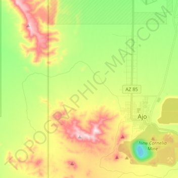
Name: Ajo topographic map, elevation, terrain.

Location: Ajo, Pima County, Arizona, 85321, United States (32.33926 -112.95094 32.44731 -112.82946)

Average elevation: 541 m

Minimum elevation: 274 m

Maximum elevation: 896 m

Other topographic maps

Click on a map to view its topography, its elevation and its terrain.

Sonoran Desert

United States > Arizona > Pima County

To the north in California and northwest Arizona, the Sonoran Desert transitions to the colder-winter, higher-elevation Mojave, Great Basin, and Colorado Plateau deserts.

Average elevation: 517 m

South Tucson

United States > Arizona > Pima County

Average elevation: 741 m

Oro Valley

United States > Arizona > Pima County > Oro Valley

Average elevation: 874 m

San Agustin

United States > Arizona > Pima County

Average elevation: 936 m

Gear up for your next adventure:

👟Sport Hiking Sandals - Breathable footwear for water crossings and camp rest
🧤Insulated Winter Gloves - Heavy-duty protection for sub-zero Canadian adventures
Bushcraft Tarp - Versatile emergency shelter or gear protection
🏃Hydration Running Vest - Carry water and maps close to your body for speed
🧴Outdoor Sunscreen - High SPF protection for high-altitude UV exposure

As an Amazon Associate, this site earns from qualifying purchases at no extra cost to you.