Geolocate

Munising topographic map

Click on the map to display elevation.

About this map
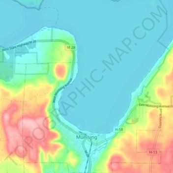
Name: Munising topographic map, elevation, terrain.

Location: Munising, Alger County, Michigan, 49862, United States (46.39838 -86.67921 46.45372 -86.60459)

Average elevation: 213 m

Minimum elevation: 176 m

Maximum elevation: 312 m

Other topographic maps

Click on a map to view its topography, its elevation and its terrain.
Kiva

United States > Michigan > Alger County

Average elevation: 310 m

Christmas

United States > Michigan > Alger County

Average elevation: 203 m

Indian Town

United States > Michigan > Alger County

Average elevation: 270 m

Gear up for your next adventure:

🌡️Emergency Mylar Blankets - Compact thermal protection for unexpected nights outdoors
🧦Hiking Liner Socks - Thin base layer to prevent friction and blisters
🔦LED Headtorch - Bright and durable light for night activities
🕶️Polarized Sunglasses - Reduces glare from snow and water at high elevations
🎒Backpack Rain Cover - External shield to keep your entire pack dry

As an Amazon Associate, this site earns from qualifying purchases at no extra cost to you.