Geolocate

Farmington topographic map

Click on the map to display elevation.

About this map
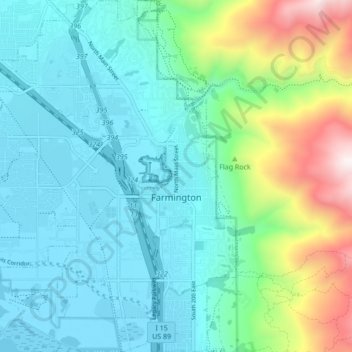
Name: Farmington topographic map, elevation, terrain.

Location: Farmington, Davis County, Utah, United States (40.95211 -111.94692 41.01653 -111.87294)

Average elevation: 1,553 m

Minimum elevation: 1,280 m

Maximum elevation: 2,507 m

Other topographic maps

Click on a map to view its topography, its elevation and its terrain.

Antelope Island

United States > Utah > Davis County

The island is accessible via a 7-mile causeway from Syracuse in Davis County. Access from Interstate 15 is via exit 332, then west along Antelope Drive (SR-108). The island's shore (all but west side of the island) is mostly flat with beaches and plains to the base of the mountains on the island. These steep…

Average elevation: 1,306 m

Quail Run

United States > Utah > Davis County > Farmington

Average elevation: 1,428 m

Farmington

United States > Utah > Davis County > Farmington > Farmington

Average elevation: 1,595 m

Hight

United States > Utah > Davis County > Farmington

Average elevation: 1,463 m

Farmington Station

United States > Utah > Davis County > Farmington

Average elevation: 1,467 m

Hight

United States > Utah > Davis County > Farmington

Average elevation: 1,463 m

Florece

United States > Utah > Davis County > Centerville

Average elevation: 1,378 m

Lakeview Hills

United States > Utah > Davis County > Farmington

Average elevation: 1,523 m

Stoney Brook

United States > Utah > Davis County > Farmington

Average elevation: 1,493 m

Gear up for your next adventure:

🏕️Camping Hammock - Integrated protection for sleeping between trees
💧Hydration Pack - Hands-free hydration system for long hikes
🧢Hiking Sun Hat - Wide-brimmed protection for exposed mountain ridges
🔋Emergency Crank Radio - Weather alerts and power without needing batteries
🥾Light Hiking Boots - Lightweight and comfortable boots for day hikes

As an Amazon Associate, this site earns from qualifying purchases at no extra cost to you.