Geolocate

Farmington topographic map

Click on the map to display elevation.

About this map

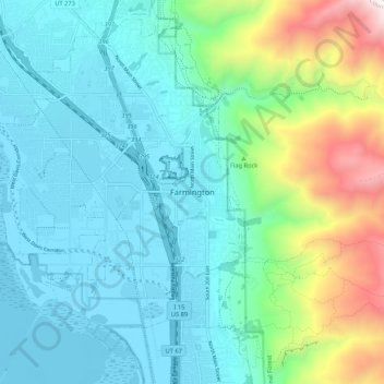
Name: Farmington topographic map, elevation, terrain.

Location: Farmington, Davis County, Utah, 84025, United States (40.94044 -111.92747 41.02044 -111.84747)

Average elevation: 1,595 m

Minimum elevation: 1,279 m

Maximum elevation: 2,731 m

Gear up for your next adventure:

🚑Survival Whistle - Signal for help across long distances in mountains
🥾Trail Hiking Shoes - Durable shoes designed for rugged trails
🛶Canoe Life Vest - Safety vest for water sports
🥾Hiking Shorts - Breathable shorts suitable for summer hikes
🥤Collapsible Travel Cup - Saves space and weight in your mess kit

As an Amazon Associate, this site earns from qualifying purchases at no extra cost to you.