
Make a donation
Gear up for your next adventure:
As an Amazon Associate, this site earns from qualifying purchases at no extra cost to you.
Meander River topographic map
Click on the map to display elevation.
Make a donation
Gear up for your next adventure:
As an Amazon Associate, this site earns from qualifying purchases at no extra cost to you.
Meander River
The settlement is located on the banks of the Hay River, at an elevation of 328 meters (1,076 ft). The plant hardiness zone of Meander River is 0B, the second lowest possible within Canada, due primarily to its northern latitude.
Make a donation
Gear up for your next adventure:
As an Amazon Associate, this site earns from qualifying purchases at no extra cost to you.
About this map
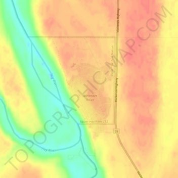
Name: Meander River topographic map, elevation, terrain.
Location: Meander River, Mackenzie County, Alberta, Canada (59.03497 -117.72398 59.05497 -117.70398)
Average elevation: 325 m
Minimum elevation: 292 m
Maximum elevation: 341 m
Mackenzie County trails, hiking, mountain biking, running and outdoor activities
Make a donation
Gear up for your next adventure:
As an Amazon Associate, this site earns from qualifying purchases at no extra cost to you.