Geolocate

Mandvi N topographic map

Click on the map to display elevation.

About this map

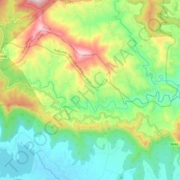
Name: Mandvi N topographic map, elevation, terrain.

Location: Mandvi N, Junnar, Pune, Maharashtra, India (19.33469 73.86648 19.35545 73.95668)

Average elevation: 939 m

Minimum elevation: 664 m

Maximum elevation: 1,455 m

Other topographic maps

Click on a map to view its topography, its elevation and its terrain.

Naneghat

India > Maharashtra > Junnar

Average elevation: 422 m

Gear up for your next adventure:

🧭GPS Tracker - Track your location in remote areas safely
🧰Emergency Multi-Tool - Compact multi-tool for outdoor survival
🥾Mountain Trail Shoes - High-traction shoes for mountain trails
🧥Waterproof Hiking Jacket - Protect yourself from rain and wind while hiking
🐕Hiking Dog Pack - Let your canine companion carry their own water and food

As an Amazon Associate, this site earns from qualifying purchases at no extra cost to you.