Geolocate

Naneghat topographic map

Click on the map to display elevation.

About this map

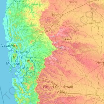
Name: Naneghat topographic map, elevation, terrain.

Location: Naneghat, Junnar, Pune District, Maharashtra, India (18.29266 72.67609 20.29266 74.67609)

Average elevation: 422 m

Minimum elevation: -2 m

Maximum elevation: 1,512 m

Other topographic maps

Click on a map to view its topography, its elevation and its terrain.

Mandvi N

India > Maharashtra > Junnar

Average elevation: 939 m

Gear up for your next adventure:

🧢Outdoor Cap - Protective cap for sun and rain during hikes
🧢Hiking Hat - Sun-protective and breathable hats for long treks
🥾Approach Shoes - Shoes designed for climbing approaches and rugged trails
🔥Camping Stove - Portable stoves to cook outdoors with ease
🧼Travel Hand Sanitizer - Keep hands clean when water is scarce

As an Amazon Associate, this site earns from qualifying purchases at no extra cost to you.