
Kihei topographic map
Click on the map to display elevation.
About this map
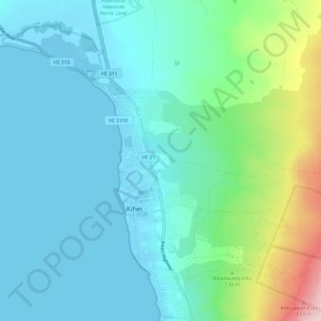
Name: Kihei topographic map, elevation, terrain.
Location: Kihei, Maui County, Hawaii, United States (20.71347 -156.49069 20.81071 -156.40079)
Average elevation: 74 m
Minimum elevation: -5 m
Maximum elevation: 405 m
Other topographic maps
Click on a map to view its topography, its elevation and its terrain.
Kula
United States > Hawaii > Maui County
Kula is a district and census-designated place (CDP) of Maui, Hawaii, that stretches across the "up-country", the western-facing slopes of Haleakalā, from Makawao to Kanaio. Most of the residential areas lie between about 500 to 1,100 m (1,600 to 3,600 ft) in elevation. The district has traditionally been…
Average elevation: 740 m
Haleakalā Observatories
United States > Hawaii > Maui County
The Haleakalā Observatory, also known as the Haleakalā High Altitude Observatory Site, is Hawaii's first astronomical research observatory. It is located on the island of Maui and is owned by the Institute for Astronomy of the University of Hawaiʻi, which operates some of the facilities on the site and…
Average elevation: 2,811 m
Kula
United States > Hawaii > Maui County
Kula is a census-designated place (CDP) of Maui, Hawaii. It stretches across Upcountry Maui, the western-facing slopes of Haleakalā. Most residential areas lie between about 500 to 1,100 m (1,600 to 3,600 ft) in elevation. The district is distinct from the generally hotter and busier coastal areas. The…
Average elevation: 740 m
Molokini Shoal Marine Life Conservation District
United States > Hawaii > Maui County
Average elevation: 0 m