Geolocate

Gandia topographic map

Click on the map to display elevation.

About this map

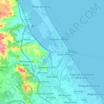
Name: Gandia topographic map, elevation, terrain.

Location: Gandia, la Safor, Valencia, Valencian Community, Spain (38.94981 -0.29715 39.04128 -0.14424)

Average elevation: 50 m

Minimum elevation: -2 m

Maximum elevation: 560 m

Other topographic maps

Click on a map to view its topography, its elevation and its terrain.

Marco

Spain > Valencian Community > Moixent / Mogente

Average elevation: 771 m

Gear up for your next adventure:

🧤Rechargeable Heated Gloves - Extreme warmth for Canadian winter expeditions
🔦LED Headtorch - Bright and durable light for night activities
🧴Waterproofing Spray - Restore the DWR coating on jackets and tents
🧣Merino Neck Gaiter - Protects against wind, sun, and cold at high altitudes
🧥Ultralight Puffy Jacket - Maximum warmth that packs down to the size of an orange

As an Amazon Associate, this site earns from qualifying purchases at no extra cost to you.