
Make a donation
Gear up for your next adventure:
As an Amazon Associate, this site earns from qualifying purchases at no extra cost to you.
Pierre Aigue topographic map
Click on the map to display elevation.
Make a donation
Gear up for your next adventure:
As an Amazon Associate, this site earns from qualifying purchases at no extra cost to you.
About this map
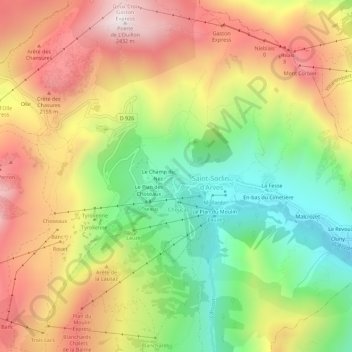
Name: Pierre Aigue topographic map, elevation, terrain.
Average elevation: 1,916 m
Minimum elevation: 1,438 m
Maximum elevation: 2,421 m
Make a donation
Gear up for your next adventure:
As an Amazon Associate, this site earns from qualifying purchases at no extra cost to you.
Other topographic maps
Click on a map to view its topography, its elevation and its terrain.
Refuge de l'Étendard
France > Auvergne-Rhône-Alpes > Savoie > Saint-Sorlin-d'Arves
Average elevation: 2,437 m
Glacier de Saint-Sorlin
France > Auvergne-Rhône-Alpes > Savoie > Saint-Sorlin-d'Arves
Average elevation: 2,912 m
Make a donation
Gear up for your next adventure:
As an Amazon Associate, this site earns from qualifying purchases at no extra cost to you.