Geolocate

Giles County topographic map

Click on the map to display elevation.

About this map

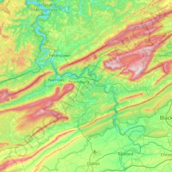
Name: Giles County topographic map, elevation, terrain.

Location: Giles County, Virginia, United States (37.14749 -81.01448 37.48167 -80.43094)

Average elevation: 703 m

Minimum elevation: 428 m

Maximum elevation: 1,314 m

Other topographic maps

Click on a map to view its topography, its elevation and its terrain.

French

United States > Virginia > Giles County > French

Average elevation: 643 m

Gear up for your next adventure:

🪑Insulated Seat Pad - Protect your seat from cold rocks and wet logs
🧦Outdoor Socks - Durable socks designed for hiking and outdoor sports
🩹Moleskin Blister Pads - Direct protection for painful foot pressure points
🧭GPS Outdoor Watch - Smart watch for navigation and fitness tracking in nature
🛌Insulated Sleeping Pad - Critical thermal barrier between you and the cold ground

As an Amazon Associate, this site earns from qualifying purchases at no extra cost to you.