Geolocate

Bayugan topographic map

Click on the map to display elevation.

About this map

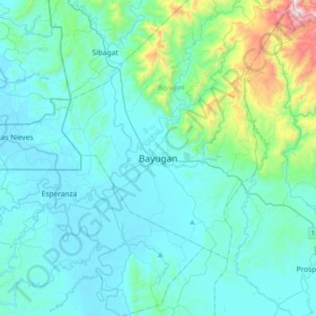
Name: Bayugan topographic map, elevation, terrain.

Location: Bayugan, Agusan del Sur, Caraga, 8502, Philippines (8.55456 125.58819 8.87456 125.90819)

Average elevation: 168 m

Minimum elevation: 4 m

Maximum elevation: 1,272 m

Gear up for your next adventure:

🥾Hiking Shorts - Breathable shorts suitable for summer hikes
🔭Compact Monocular - One-handed bird watching and trail spotting
🛁Quick-Dry Microfiber Towel - Space-saving towel that dries rapidly on the move
🧥Softshell Hiking Jacket - The perfect balance of wind protection and breathability
🧥Fleece Jacket - Warm and lightweight jacket for layering

As an Amazon Associate, this site earns from qualifying purchases at no extra cost to you.