
Make a donation
Gear up for your next adventure:
As an Amazon Associate, this site earns from qualifying purchases at no extra cost to you.
Huzur Tahsil topographic map
Click on the map to display elevation.
Make a donation
Gear up for your next adventure:
As an Amazon Associate, this site earns from qualifying purchases at no extra cost to you.
About this map
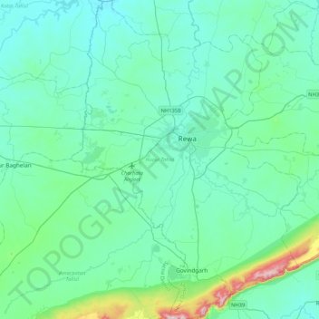
Name: Huzur Tahsil topographic map, elevation, terrain.
Location: Huzur Tahsil, Rewa, Madhya Pradesh, India (24.31992 81.14091 24.70077 81.44264)
Average elevation: 325 m
Minimum elevation: 270 m
Maximum elevation: 680 m
Make a donation
Gear up for your next adventure:
As an Amazon Associate, this site earns from qualifying purchases at no extra cost to you.
Other topographic maps
Click on a map to view its topography, its elevation and its terrain.
Rewa
India > Madhya Pradesh > Huzur Tahsil
Rewa is located on 24°32′17″N 81°17′43″E / 24.53806°N 81.29528°E / 24.53806; 81.29528. It has an average elevation of 259 metres (853 feet). Rewa is situated on Bank of Bihad and Bichhiya river, it's on rewa pletaue sarounded with and vindhya and kaimur ranges .
Average elevation: 317 m