Geolocate

Bosque County topographic map

Click on the map to display elevation.

About this map

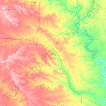
Name: Bosque County topographic map, elevation, terrain.

Location: Bosque County, Texas, United States (31.58764 -98.00518 32.20701 -97.27728)

Average elevation: 265 m

Minimum elevation: 128 m

Maximum elevation: 429 m

Other topographic maps

Click on a map to view its topography, its elevation and its terrain.

Cayote

United States > Texas > Bosque County

Average elevation: 225 m

Kopperl

United States > Texas > Bosque County

Average elevation: 176 m

Laguna Park

United States > Texas > Bosque County

Average elevation: 175 m

Mosheim

United States > Texas > Bosque County

Average elevation: 286 m

Gear up for your next adventure:

🥘Camping Cookware Set - Compact nesting pots and pans for trail cooking
🧢Hiking Hat - Sun-protective and breathable hats for long treks
🧢Outdoor Visor - Breathable visor for sunny hikes
🧥Thermal Fleece Jacket - Versatile insulation for changing mountain temperatures
🧥Packable Rain Jacket - Breathable waterproof layer for unpredictable weather

As an Amazon Associate, this site earns from qualifying purchases at no extra cost to you.