Geolocate

Lake Constance topographic map

Click on the map to display elevation.

About this map

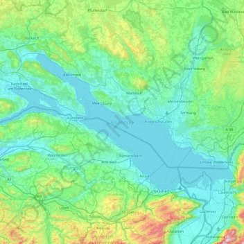
Name: Lake Constance topographic map, elevation, terrain.

Location: Lake Constance, Bodenseekreis, Baden-Württemberg, Germany (47.47806 8.85870 47.81752 9.75383)

Average elevation: 555 m

Minimum elevation: 389 m

Maximum elevation: 1,490 m

Other topographic maps

Click on a map to view its topography, its elevation and its terrain.

Berg

Germany > Baden-Württemberg > Bodenseekreis

Average elevation: 443 m

Gear up for your next adventure:

🥾Light Hiking Boots - Lightweight and comfortable boots for day hikes
🥾Trail Running Shoes - Lightweight and durable shoes for trail running
Lightweight Camping Tent - Portable shelter optimized for Canadian backcountry camping
Backpacking Tent - Lightweight tent for long-distance hiking trips
🧥Softshell Hiking Jacket - The perfect balance of wind protection and breathability

As an Amazon Associate, this site earns from qualifying purchases at no extra cost to you.