Geolocate

Berg topographic map

Click on the map to display elevation.

About this map
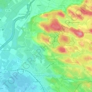
Name: Berg topographic map, elevation, terrain.

Location: Berg, Kressbronn am Bodensee, Verwaltungsverband Eriskirch-Kressbronn am Bodensee-Langenargen, Bodenseekreis, Baden-Württemberg, 88079, Germany (47.58894 9.58478 47.62894 9.62478)

Average elevation: 443 m

Minimum elevation: 396 m

Maximum elevation: 530 m

Other topographic maps

Click on a map to view its topography, its elevation and its terrain.

Tettnang

Germany > Baden-Württemberg > Bodenseekreis

Average elevation: 457 m

Tettnang

Germany > Baden-Württemberg > Bodenseekreis

Average elevation: 457 m

Gear up for your next adventure:

🧣Evaporative Cooling Towel - Beat the heat during intense summer climbs
🥾Hiking Shoes - Durable and comfortable shoes for trail hiking
🧭GPS Tracker - Track your location in remote areas safely
🧳Compression Sacks - Maximize space in your backpack by shrinking gear
🎒Hiking Daypack - Lightweight and durable backpacks for day trips and excursions

As an Amazon Associate, this site earns from qualifying purchases at no extra cost to you.