
Make a donation
Gear up for your next adventure:
As an Amazon Associate, this site earns from qualifying purchases at no extra cost to you.
Walker Lake topographic map
Click on the map to display elevation.
Make a donation
Gear up for your next adventure:
As an Amazon Associate, this site earns from qualifying purchases at no extra cost to you.
Walker Lake
These diversions have resulted in a severe drop in the lake's level. According to the USGS, the level dropped approximately 181 ft (55 m) between 1882 and 2016. By June 2016, the lake level was 3,909 feet (1,191 m) above sea level, the lowest lake elevation since measurement began in 1882. As of 2022, Walker Lake has decreased by 90% in volume and more than 50% by surface area. A lake that was once 1/2 the area of Lake Tahoe is now 1/4 the area.
Make a donation
Gear up for your next adventure:
As an Amazon Associate, this site earns from qualifying purchases at no extra cost to you.
About this map
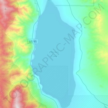
Name: Walker Lake topographic map, elevation, terrain.
Location: Walker Lake, Schurz, Mineral County, Nevada, United States (38.59588 -118.77200 38.80039 -118.66408)
Average elevation: 1,531 m
Minimum elevation: 1,199 m
Maximum elevation: 2,942 m
Make a donation
Gear up for your next adventure:
As an Amazon Associate, this site earns from qualifying purchases at no extra cost to you.