Geolocate

Nijmegen topographic map

Click on the map to display elevation.

About this map

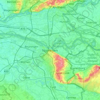
Name: Nijmegen topographic map, elevation, terrain.

Location: Nijmegen, Gelderland, Netherlands, 6511KA, Netherlands (51.68749 5.70378 52.00749 6.02378)

Average elevation: 16 m

Minimum elevation: 2 m

Maximum elevation: 101 m

Other topographic maps

Click on a map to view its topography, its elevation and its terrain.

Nijmegen

Netherlands > Gelderland > Nijmegen

Average elevation: 19 m

Nijmegen

Netherlands > Gelderland > Nijmegen

Average elevation: 19 m

Stadscentrum

Netherlands > Gelderland > Nijmegen

Average elevation: 21 m

Gear up for your next adventure:

💧Hydration Bladder - Hands-free hydration solution for long treks
🛌Insulated Sleeping Pad - Critical thermal barrier between you and the cold ground
🧥Fleece Jacket - Warm and lightweight jacket for layering
🔦LED Headtorch - Bright and durable light for night activities
🚲Bike Repair Kit - Essential tools for on-trail mechanical issues

As an Amazon Associate, this site earns from qualifying purchases at no extra cost to you.