Geolocate

Nijmegen topographic map

Click on the map to display elevation.

About this map

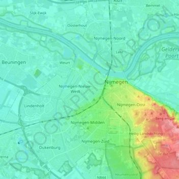
Name: Nijmegen topographic map, elevation, terrain.

Location: Nijmegen, Gelderland, Netherlands (51.79059 5.75762 51.89462 5.90835)

Average elevation: 19 m

Minimum elevation: 3 m

Maximum elevation: 95 m

Other topographic maps

Click on a map to view its topography, its elevation and its terrain.

Kops Plateau

Netherlands > Gelderland > Nijmegen

Average elevation: 36 m

Nijmegen

Netherlands > Gelderland > Nijmegen

Average elevation: 16 m

Stadscentrum

Netherlands > Gelderland > Nijmegen

Average elevation: 21 m

Gear up for your next adventure:

🧭Orienteering Kit - Tools for map reading and navigation in the wild
🚲MTB Frame Bag - Carry tools and maps directly on your bicycle frame
🧣Merino Neck Gaiter - Protects against wind, sun, and cold at high altitudes
🧴Bear Spray Holster - Quick-access carry for essential Canadian wilderness safety
🦟Insect Repellent - Keep mosquitoes and black flies away in wooded areas

As an Amazon Associate, this site earns from qualifying purchases at no extra cost to you.