
Lavey-Morcles topographic map
Interactive map
Click on the map to display elevation.
About this map
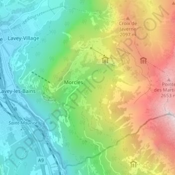
Name: Lavey-Morcles topographic map, elevation, terrain.
Location: Lavey-Morcles, District d'Aigle, Vaud, 1892, Switzerland (46.18707 7.00814 46.22805 7.07170)
Average elevation: 1,286 m
Minimum elevation: 406 m
Maximum elevation: 2,928 m
Other topographic maps
Click on a map to view its topography, its elevation and its terrain.
Villars-sur-Ollon
Switzerland > Vaud > District d'Aigle
Villars-sur-Ollon, Ollon, District d'Aigle, Vaud, 1884, Switzerland
Average elevation: 1,293 m
Bex
Switzerland > Vaud > District d'Aigle
Bex, District d'Aigle, Vaud, 1880, Switzerland
Average elevation: 1,153 m
Ormont-Dessous
Switzerland > Vaud > District d'Aigle
Ormont-Dessous, District d'Aigle, Vaud, Switzerland
Average elevation: 1,518 m
Aigle
Switzerland > Vaud > District d'Aigle
Aigle, District d'Aigle, Vaud, 1860, Switzerland
Average elevation: 647 m