Geolocate

Dubbo topographic map

Click on the map to display elevation.

About this map

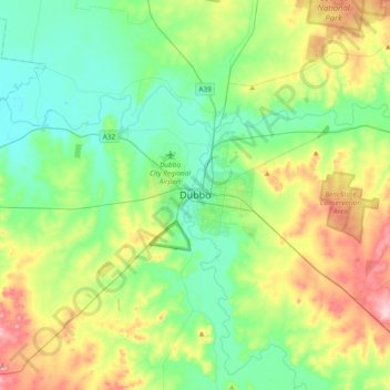
Name: Dubbo topographic map, elevation, terrain.

Location: Dubbo, Dubbo Regional Council, New South Wales, Australia (-32.40790 148.44265 -32.08790 148.76265)

Average elevation: 307 m

Minimum elevation: 244 m

Maximum elevation: 454 m

Gear up for your next adventure:

🛁Quick-Dry Microfiber Towel - Space-saving towel that dries rapidly on the move
🏕️Camping Hammock - Integrated protection for sleeping between trees
🥾Hiking Boots - Sturdy boots providing ankle support and traction on rugged trails
🧦Hiking Liner Socks - Thin base layer to prevent friction and blisters
🛶Kayak Dry Bag - Waterproof storage for kayaking adventures

As an Amazon Associate, this site earns from qualifying purchases at no extra cost to you.