Geolocate

Why topographic map

Click on the map to display elevation.

About this map

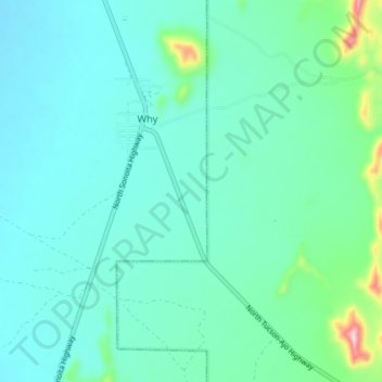
Name: Why topographic map, elevation, terrain.

Location: Why, Hickiwan, Pima County, Arizona, United States (32.22464 -112.76032 32.28590 -112.70208)

Average elevation: 566 m

Minimum elevation: 523 m

Maximum elevation: 785 m

Other topographic maps

Click on a map to view its topography, its elevation and its terrain.

Castle Mountains

United States > Arizona > Pima County > Hickiwan

Average elevation: 741 m

Gear up for your next adventure:

🧥Packable Rain Jacket - Breathable waterproof layer for unpredictable weather
🧴Insect Repellent - Protect yourself from bugs during outdoor adventures
🥾Waterproof Hiking Boots - Essential footwear for rugged terrain and wet Canadian trails
🧢Beanie Hat - Keep your head warm in cold weather
🩹Moleskin Blister Pads - Direct protection for painful foot pressure points

As an Amazon Associate, this site earns from qualifying purchases at no extra cost to you.